
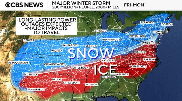
Winter Storm Forecast for Washington Area
The Washington area is bracing for a substantial winter storm this weekend, with predictions of 7 to 14 inches of snow accompanied by ice, according to the National Weather Service.
The storm is expected to arrive around 11 p.m. on Saturday and continue until 4 a.m. on Monday. The heaviest snowfall is anticipated on Sunday, with rates reaching up to 1 to 2 inches per hour. Ice accumulation is expected to be between 0.1 and 0.2 inches.
The incoming snow, moving northeast from the southwest, will likely mix with sleet and freezing rain on Sunday.
A prolonged wind chill dropping into the teens or single digits will begin Friday night and persist into the following week, raising concerns about significant icing.
The highest risk for icing will be south of U.S. Route 50, while the most substantial snowfall is predicted for the far northern and western suburbs of Washington and Baltimore.
Dominion Energy has warned residents about potential widespread power outages due to heavy ice and snow accumulation across Virginia and northeastern North Carolina, stating that restoration efforts could take several days.
Exelon subsidiaries Pepco and Baltimore Gas and Electric are also preparing for disruptions in service, prioritizing public safety along with essential services such as hospitals and emergency centers.
D.C. Mayor Muriel Bowser, Maryland Governor Wes Moore, and Virginia Governor Abigail Spanberger have all declared states of emergency in anticipation of the storm. Residents are advised to remain indoors and limit travel whenever possible.
D.C. residents must relocate their vehicles off designated snow emergency routes by noon on Saturday when the city’s snow emergency takes effect. This emergency status will remain in place until Tuesday at 9:30 a.m.


